
Northern Vanduneez: Difference between revisions
No edit summary |
No edit summary |
||
| Line 3: | Line 3: | ||
<imagemap> | <imagemap> | ||
File:Northern_Vanduneez_WIKI.png|800px|center|Map of Sundering of the Gods | File:Northern_Vanduneez_WIKI.png|800px|center|Map of Sundering of the Gods | ||
rect 830 126 1170 220 [[Kaludor|Kaludor]] | |||
rect 1056 380 1355 530 [[Eleris- The Mother Wood|Kûtu]] | |||
rect 580 620 1054 702 [[Tek Regions|Tek Regions]] | |||
rect 1090 680 1320 810 [[Sobômu|Sobômu]] | |||
rect 230 950 415 1000 [[Helebôm|Helebôm]] | |||
rect 721 951 1148 1055 [[Dragonspan Mountains|Dragonspan Mountains]] | |||
rect 450 950 656 1049 [[Ilû-Strono|Ilû-Strono]] | |||
rect 1150 920 1385 960 [[Rondilê Hills|Rondilê Hills]] | |||
rect 1450 730 1650 820 [[Iludetrê Highlands|Iludetrê Highlands]] | |||
rect 654 1180 950 1235 [[Hi'si Plains|Hi'si Plains]] | |||
rect 1054 1107 1277 1232 [[Modôwî Forests|Modôwî Forests]] | |||
rect 1646 1011 1860 1104 [[Gorotan Penninsula|Gorotan Penninsula]] | |||
rect 1697 1400 1900 1435 [[Nevjuwaru|Nevjuwaru]] | |||
rect 260 1155 445 1241 [[Medrisên Sea|Medrisên Sea]] | |||
rect 880 1435 1310 1490 [[Monsoon Straits|Monsoon Straits]] | |||
rect 1420 1015 1596 1173 [[Gulf of Tomulok|Gulf of Tomulok]] | |||
desc bottom-right | desc bottom-right | ||
</imagemap> | </imagemap> | ||
Latest revision as of 20:46, 22 April 2025
Northern Vanduneez[edit | edit source]
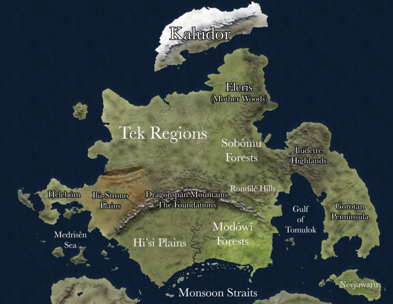
You can hover over the map in Named Locations and click, or go straight to location pages with the links below.
Regions[edit | edit source]
- Kaludor
- Eleris- The Mother Wood
- Tek Regions
- Sobômu Forests
- Helebôm
- Dragonspan Mountains- The Foundations
- Ilû-Strono Plains
- Rondilê Hills
- Iludetrê Highlands
- Hi'si Plains
- Modôwî Forests
- Gorotan Penninsula
- Nevjuwaru
Bodies of Water[edit | edit source]
Description from www.sunderingthegods.com
Northern Vandunêz is a continent with a widely diverse population of peoples ranging from the Êdân and their cousin elves that dominate the vast forest on the eastern coast to the numerous Tek Nations to the Eight Kingdomer Dwarves and the boar-like Mexûk of the Mîsunik jungles of the south. With these and several other cultures ranging the lands, conflict and war are a near constant even without wilds teeming with dangerous creatures.
The Dragon Span Mountains which are home to the Eight Kingdoms are a natural barrier between north and south, with the north generally being more civilized during the first several hundred years of the F.E., due to the Tek Nations and Êdân dominating up there. The wet tropical belt south of the Dragon Spans is a lush plain overrun by powerful tribes of a variety of creatures, which keep the more mannish races' advancement held back.
On the Lœsî Peninsula of the southeast are two peoples, the Gôrôtan and Listôlên, who are at odds with each other at every turn, with the Gôrôtan holding the fertile rolling hills and the Listôlên the forested and more mountainous north. The Gôrôtan city-states of the early F.E. are easily the most civilized people of the south until the arrival of the Silonê migration circa 504 F.E.
To the north of the mainland continent lies the Island of Kaludor which is dominated by the Silonê Clans until 502 F.E. Cataclysmic events drive the Silonê from the island at this date, although a few remain behind, and this people finds themselves on a long and bloody journey to a new homeland in the south.
A short distance to the northwest of the Dragon Spans lies another geographic landmark, a mirror of sorts of the mountains, known simply as the Orstân Rift. This great canyon is routinely over a mile deep, as wide as thirty miles at points, and is several hundred miles long. The Rift during the F.E. serves as a natural barrier to the Tek Nations, giving the Ûlstrwar and Ilu-Sivztro a defensible haven from their northern neighbors.